Bridgeville/Greenwood Hit Saturday by EF 3 Tornado
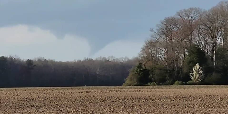
The National Weather Service has issued it’s assessment on the tornado that rated EF 3 on the Enhanced Fujita Scale – that’s a “strong” tornado – with 136 to 165mph winds.
Assessment from the National Weather Service on the Bridgeville-Ellendale Tornado…
Rating: EF-3
Estimated Peak Wind: 140 mph
Path Length /statute/: 14.3 miles
Path Width /maximum/: 700 yards (0.4 miles)
Fatalities: 1
Injuries: 0
Start Date: April 1, 2023
Start Time: 5:59 PM EDT
Start Location: Bridgeville / Sussex County / DE
Start Lat/Lon: 38.7570 / -75.6398
End Date: April 1, 2023
End Time: 6:19 PM EDT
End Location: Ellendale / Sussex County / DE
End Lat/Lon: 38.8180 / -75.3892
The Bridgeville-Ellendale Tornado began around 5:59 PM EDT near the intersection of Polk Road and Dublin Hill Road where a section of a small barn roof was blown off. The tornado continued east-northeast crossing Seashore Highway. Along this section of the damage path, a couple wooden power poles were blown down along with several trees uprooted or snapped. One tree fell onto a house causing significant collateral roof damage. The tornado continued eastward paralleling Newton Road where a farmstead sustain significant tree damage. About a half dozen parked semi-trailers were blow over along a driveway. Farther east, more tree damage and snapped power poles were observed. Near the intersection of Precious Lane and Newton Road, a 2 story house was collapsed after appearing to have slid off its foundation. A small outbuilding was also severely damaged nearby. Debris from this area was blown several hundred yards east into nearby fields. Another farmstead was struck by the tornado as it continued east on Dale Farm Road. A large barn had 2 exterior walls blown out and a smaller shed was blown over. Several trees were also snapped or uprooted on the property.
The tornado continued east, crossing a railroad track and impacting a Delaware Department of Transportation facility. Along the railroad track, a half dozen or more wooden high tension power poles were snapped and collapsed along with 2 steel high tension power poles. This is where the tornado’s estimated peak wind speeds of 140 mph were reached. The DELDOT facility sustained significant damage. A maintenance garage building experienced a collapse of an exterior wall and large portion of its roof. 2 smaller garage buildings nearby experienced several garage doors blown out, roofing material removal, and exterior wall damage. A building storing road salt had it’s roof completely destroyed. The facility’s office building had a few windows blown out, siding, and roofing material blown off. Some of the siding material was found embedded into the ground downstream where a Delaware Environmental Observing System (DEOS) mesonet gauge measured a 98 mph wind gust at 3 meters (~10 feet) above the ground at 6:05 PM EDT.
The tornado continued across a field, then crossed US Route 13 where a few utility poles were snapped. The tornado continued east into a wooded area where significant tree damage occurred. Numerous trees were snapped, one of which fell onto a double-wide manufactured home. After continuing through the wooded area, the tornado emerged into a field along Sugar Hill Road. A house along the road sustained significant roof removal, exterior wall damage, and blown out windows. A small outbuilding sustained roof material removal and several trees near the house were snapped or uprooted. The tornado continued across Sugar Hill Road and east into another field where 2 irrigation pivots were blown over. The tornado emerged into a wooded residential area along Fawn Road where the tornado appeared to have intensified. The tornado cause significant uprooted and snapped trees in the area as well as significant removal of roofing material and blown out windows to some of the single-family houses along Fawn Road. Farther east, the significant tree damage continued and a large detached garage collapsed.
The tornado continued northeast toward the northern extension of Fawn Road where more significant tree damage occurred. A single story single family home appeared to have slid off its foundation and collapsed. A few other homes sustained roofing material and other cosmetic material blown off. The tornado continued east into another wooded residential area along Quail Hollow Road where mostly significant tree damage occurred. Numerous trees were snapped or uprooted. One snapped tree fell into a house causing significant collateral damage. On large detached garage was severely damaged with exterior walls and roof collapse near Tuckers Road And Quail Hollow Road.
The tornado moved northeast from this area into a wooded area just south of Tuckers Road, emerging into an open field. This was the point where the tornado reached its maximum with of about 700 yards (~0.4 miles). The tornado struck a small farmstead along Tuckers Road. The house appeared to have slide off its foundation and collapsed. 2 barns on the property were completely destroyed along with snapped trees and power poles. Farther east, several homes sustained damage from fallen trees and wind blowing off roof material. A few irrigation pivots were blown over in this area.
Numerous trees were snapped or uprooted along Owens Road and Sharps Mill Road near Tuckers Road. Just east of Tuckers Road, a single family house sustained significant structural damage. A large section of roof was blown off and an exterior wall was partially blown out. Several windows were blown out and the vinyl fencing on the property was almost completely blown away. A few more trees and minor cosmetic damage to structures occurred a few hundred yards east of Tuckers Road as the tornado continued northeast. Another residence was struck by the tornado on Tuckers Road where a large portion of exterior wall along the attic was blown off. The home’s chimney was also blown off and a few windows were blown out. A detached garage on the property had its roof almost completely blown off. A chicken house behind the residence had a small portion of its roof blown off. Some trees were uprooted along a tree line before the tornado moved into a large and inaccessible wooded area.
The tornado appeared to have maintained a fairly steady intensity as it continued northeast toward Ellendale while crossing several roads. The tornado crossed Oak Road, B and R Road, Oakley Road, Union Church Road, and Beaver Dam Road. Along these road crossings, the tornado produced consistent tree damage and some minor cosmetic damage to some homes. More notable areas of damage include: a large chicken house along B and R Road was severely damaged with some collapse of the northern end of the structure; A house along Oakley Road had an exterior garage wall pushed inward; more significant tree damage was also noted along Oakley Road; and a small portion of a single family house was blown off on Beaver Dam Road.
The tornado crossed US Route 113 into Ellendale where sporadic tree damage occurred in a residential area along Sharons Road. An entire attached garage roof and walls were blown off on a single family home on Pin Oak Street near Sharons Road. Some other houses sustained roof material blown off in this area. The tornado crossed Beach Highway/Main Street near Old State Road where some minor tree damage occurred and some shingles were blown off of a few homes. The tornado crossed Washington Avenue and McCaulley Avenue where a small portion of roof material was blown off of a free standing garage. The tornado began to weaken considerably moving northeast of downtown Ellendale. It crossed Ponder Road where some roof material was blown off of a automotive service building. The tornado continued into a wooded area then crossed Holly Tree Road emerging into a field. The tornado circulation dissipated around 6:19 PM EDT just after turning over an irrigation pivot near Hummingbird Road and Benson Road.
One fatality occurred from this tornado, but no other known serious injuries occurred.
Some Delaware tornado statistics from the National Weather Service
Tornado statistics for Delaware since 1950:
The only other recorded fatality in a tornado in Delaware occurred with an F2 tornado on July 21, 1983 near Hartley in Kent County.
The strongest tornado on record in Delaware struck on April 28, 1961 in New Castle. It had an F3 rating based upon it having destroyed a 13-inch wall of a warehouse and having tossed large doors from the
warehouse two blocks away. It also damaged several house roofs.
The longest track tornado on record in Delaware struck Kent and New Castle Counties on June 7, 1988. It traveled 23 miles from the area of Summit Airport to near Woodland Beach and had an intensity of F1.
The two widest tornadoes previously on record in Delaware were the EF2 tornadoes which struck the state on August 4, 2020 during Tropical Storm Isaias, both of which had widths of 500 yards.
Historically, Delaware has gone multiple years without any tornadoes, only to then have multiple occur in a short time. There were no tornadoes for about a 7 year period between September 28, 2004 and August 27, 2011. Delaware had 5 tornadoes in a single day during Tropical Storm Isaias, the most daily on record. The most in a year were 6 in 1992 and 2020.
The National Weather Service survey team would like to thank the Delaware Emergency Management Agency and Sussex County Emergency Management Agency for their assistance with this survey.