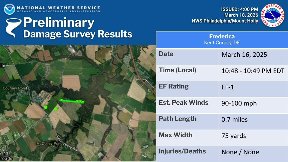
UPDATE: National Weather Service Confirms 2 EF-1 Tornadoes in Ridgely & Frederica
UPDATED – 03/18/26 –
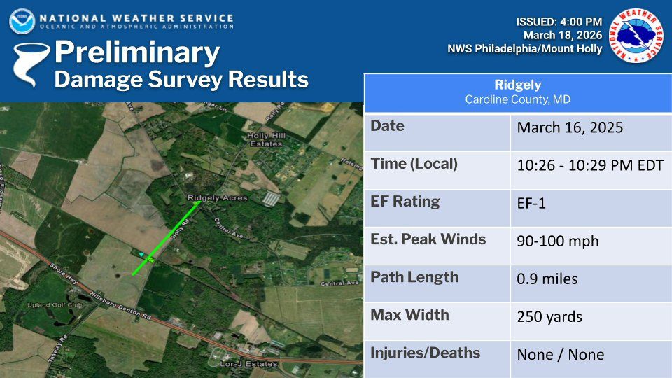
.Ridgely Maryland Thunderstorm Wind…
Peak Wind /E/: 80-90 mph
Path Length /statute/: 0.22 miles
Path Width /maximum/: 75 yards
Fatalities: 0
Injuries: 0
Start Date: March 16, 2026
Start Time: 10:24 PM EDT
Start Location: 2.4 miles SSW Ridgely / Caroline County / MD
Start Lat/Lon: 38.9147 / -75.9027
End Date: March 16, 2026
End Time: 10:24 PM EDT
End Location: 2.3 miles S Ridgely / Caroline County / MD
End Lat/Lon: 38.9154 / -75.8987
Survey Summary:
A brief area of significant wind damage occurred along Saathoff Road. The start of the path of wind damage involved the complete roof removal of a farm outbuilding with one wall collapsed inward. Metal roofing material was then scattered downstream to the east into an open field. Beyond the open field, there was some tree damage including one softwood tree snapped at the trunk. Additional damage beyond this tree line along Saathoff Road quickly lessened showing the end of the path of significant wind damage. This damage was separate but approximately 1.3 miles west of the starting point of the Ridgely tornado.
.Millington Road Thunderstorm Wind…
Peak Wind /E/: 80-90 mph
Path Length /statute/: 1.9 miles
Path Width /maximum/: 1 mile
Fatalities: 0
Injuries: 0
Start Date: March 16, 2026
Start Time: 10:24 PM EDT
Start Location: 1.8 miles NW Sudlersville / Queen Anne’s / MD
Start Lat/Lon: 39.2084 / -75.8807
End Date: March 16, 2026
End Time: 10:29 PM EDT
End Location: 2.2 miles N Sudlersville / Queen Anne’s / MD
End Lat/Lon: 39.2192 / -75.8474
Survey Summary:
Along Coleman Road, the start of significant wind damage occurred as multiple trees were uprooted and large tree branches were snapped. A farm outbuilding also experienced removal of metal roofing that was scattered to the east into an open field. As the swath of wind damage continued, there was additional farm outbuilding damage near Mud Ford Lane as the roof of an outbuilding was removed with the debris being scattered to the east up to half a mile away. It was at this point that the damage path width was at its widest, with about one mile from the damage on Coleman Road to the damage on Mud Ford Lane.
The damage continued towards Millington Road where multiple power poles were snapped, large tree branches were snapped, and additional metal roofing was peeled off a farm outbuilding. Significant wind damage was estimated to have ended near Higman Mill Road as the last point of damage was metal roofing removed from another farm outbuilding.
.Camden Delaware Thunderstorm Wind…
Peak Wind /E/: 90-100 mph
Path Length /statute/: 0.7 miles
Path Width /maximum/: 400 yards
Fatalities: 0
Injuries: 1
Start Date: March 16, 2026
Start Time: 10:39 PM EDT
Start Location: 5.0 miles W Camden / Kent / DE
Start Lat/Lon: 39.1107 / -75.6362
End Date: March 16, 2026
End Time: 10:40 PM EDT
End Location: 4.3 miles W Camden / Kent / DE
End Lat/Lon: 39.1133 / -75.6228
Survey Summary:
Tree damage was first observed on Honeysuckle Road just south of the intersection with Westville Road. The highest degree of damage was noted near the intersection of Probst Lane and Westville Road. Several trees were snapped, including multiple trees that fell onto mobile homes. One injury was reported in this location. Sporadic tree damage was observed further east near and along Quail Run. Based on the debris direction, this was determined to be straight line wind damage.
=============================================================
UPDATED – 03/17/26 – 8:45pm – Monday night saw two EF-1 tornadoes – one in Caroline County, Maryland and one in Kent County, Delaware as well as extensive straight-line wind damage in Queen Anne’s County, Maryland.
The survey team from the National Weather Service office has confirmed a tornado occurred Monday evening near Frederica. The preliminary rating is an EF-1 with estimated maximum wind speed of 100mph.
Additional extensive wind damage near Camden, Delaware remains under review. Preliminary estimate of maximum wind speed in this area is 100mph. A determination if this was straight line wind or tornado damage will be coming later.
Earlier Tuesday the survey team confirmed a tornado occurred Monday evening in Ridgely, Maryland in Caroline County. The preliminary rating of this tornado is an EF-1 with maximum winds to 100mph.
The survey team also examined significant wind damage that occurred between Sudlersville and Millington in Maryland in Queen Anne’s County. The preliminary result is that extensive straight-
line winds occurred with speeds between 70-90mph.
A final assessment including all of the details are expected to be completed and transmitted via a Public Information Statement on Wednesday.
=============================================================
UPDATED – 03/17/26 – 3:50pm – The National Weather Service survey team has confirmed an EF-1 tornado in Caroline County and excessive straight-line wind damage confirmed in Queen Anne’s County. Preliminary results show the EF-1 tornado had maximum winds to 100mph. The survey team also examined significant wind damage that occurred between Sudlersville and Millington in Queen Anne’s County – extensive straight-line winds occurred with speeds between 70 – 90mph. Results from Kent County, Delaware should be completed later this evening.
=============================================================
UPDATED – 03/17/26 – 12pm – The National Weather Service will make a Storm Damage Survey today for portions of Maryland’s Eastern Shore to central Delaware. The survey is for some areas of Queen Anne’s, Caroline and Talbot counties in Maryland to Kent County in Delaware. The survey is in relation to a severe squall line that raced across the region Monday night.
A final assessment including results of the survey are expected to be completed and transmitted via a Public Information Statement sometime this afternoon or this evening.
=============================================================
ORIGINAL STORY – 03/17/26 – Delmarva was whipped with wind and rain through the afternoon hours causing many school districts to dismiss early or cancel after-school activities. However as darkness fell – tornado warnings and severe thunderstorm warnings went into effect across Delmarva. The worst of the weather moved from Dorchester, Talbot and Caroline Counties towards the east and moved from the Seaford area towards Milford and north. There were a couple of tornado warnings with possible radar indicated rotation that moved from the mid-shore of Maryland into Delaware across northern Sussex and Kent Counties.
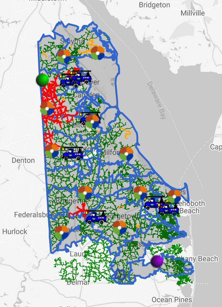
Outages for DEC at 11:30pm
-
At 1022 PM EDT, a severe thunderstorm capable of producing a tornado was located over Queen Anne, or 11 miles southeast of Centerville, moving east at 55 mph.
-
At 1035 PM EDT, a severe thunderstorm capable of producing a tornado was located over Sandtown, or 12 miles southwest of Dover, moving east at 55 mph.
A line of thunderstorms stretched from Accomack County, VA north into New Castle County, DE.
Delmarva Power and Delaware Electric Cooperative reported thousands of outages many thanks to downed wires and wind. Many outages were along the MD / DE state line from Seaford to Greenwood as well as the Coastal Club Community west of Lewes. In Kent County there were many outages along the state line from Sandtown north to Marydel (the big patch of red on the map).
The watches and warnings were all allowed to expire by 11:30 as the storms moved off the coast.
Here’s some of the highlights from the National Weather Service Reports:
- 5:45pm – marine thunderstorm wind 43mph wind gust – Indian Beach / Dewey Beach area
- 10:04pm – 55mph wind gust – Tilghman Island / Talbot county / Wunderground station
- 10:25pm – Thunderstorm wind gust 61mph – SSE Queen Anne in Talbot County / Wunderground station
- 10:27pm – Greensboro, MD / Caroline County – thunderstorm wind damage – significant tree damage / Time estimated from radar
- 10:50pm – Thunderstorm wind gust 66mph 1mi WSW Cheswold (north of Dover) / AWOS (Surface Weather Observation Station)
- 10:55pm – Thunderstorm wind gust 66mph – Dover Air Force Base / AWOS