UPDATED 9am: Whiteout Conditions Thursday Morning

UPDATED – 9am – …Whiteout conditions occurring this morning along coastal New Jersey and Delaware and unnecessary travel is highly discouraged this morning…
Moderate to heavy snow continues to occur across coastal New Jersey and Delaware, with snowfall rates of 1 to 2 inches per hour. Visibilities at 810 AM have lowered to one half mile or less in many locations due to heavy snow and considerable blowing and drifting snow. Northerly winds will gust up to 45 miles per hour, to possibly as high as 60 miles per hour within a mile of the Atlantic coast. This is resulting in very dangerous conditions, and a Blizzard Warning remains in effect.
Snow will taper off during mid or late afternoon but considerable blowing and drifting snow will continue into tonight.
=====================================================
UPDATED – 5:56am – Near blizzard conditions developing this morning along coastal New Jersey and Delaware and unnecessary travel is highly discouraged this morning…
Snow was intensifying and spreading ashore across coastal New Jersey and coastal Delaware. Visibilities at 545 AM were already one quarter to one half mile and will occasionally drop below a quarter mile in heavy snow and blowing snow. Northerly winds will frequently gust over 40 miles an hour…to possibly as high as 60 miles an hour within a mile of the Atlantic.
Snow will taper off during mid or late afternoon but potentially severe blowing and drifting will continue tonight through Friday evening as temperatures plunge and wind chills drop to 5 below zero.
======================================================
UPDATED – 3:30PM – BLIZZARD WARNING IN EFFECT NOW UNTIL 7PM EST THURSDAY…
* WHAT…Blizzard conditions expected. Travel will be very dangerous to impossible, including during the morning commute on Thursday. Tree branches could fall as well. Total snow
accumulations of 6 to 10 inches are expected, with locally higher amounts up to 12 inches.
* WHERE…Sussex County, Delaware, Wicomico, Somerset, Inland Worcester and Maryland Beaches Counties.
* WHEN…From 7 PM this evening to 1 PM EST Thursday.
* ADDITIONAL DETAILS…Winds gusting as high as 50 mph will cause whiteout conditions in blowing snow. Significant drifting of the snow is likely.
PRECAUTIONARY/PREPAREDNESS ACTIONS… A Blizzard Warning means severe winter weather conditions are expected or occurring. Falling and blowing snow with strong winds and poor visibilities are likely. This will lead to whiteout conditions, making travel extremely dangerous. Do not travel. If you must travel, have a winter survival kit with you. If you get
stranded, stay with your vehicle. The latest road conditions for the state you are calling from can be obtained by calling 5 1 1.
==================================================
UPDATED: …WINTER STORM WARNING IN EFFECT FROM 7 PM THIS EVENING TO 5 PM
EST THURSDAY…
* WHAT…Heavy snow and blowing snow expected. Plan on difficult travel conditions, including during the morning commute on Thursday. Tree branches could fall as well. Total snow
accumulations of 4 to 6 inches are expected.
* WHERE…Inland Sussex and Delaware Beaches counties.
* WHEN…From 7 PM this evening to 5 PM EST Thursday.
* ADDITIONAL DETAILS…Winds gusting as high as 50 mph will cause areas of blowing and drifting snow causing significantly reduced visibilities. Scattered power outages could develop Thursday and Friday which would force considerable hardship where heat would not be available.
PRECAUTIONARY/PREPAREDNESS ACTIONS… A Winter Storm Warning for snow and blowing snow means severe winter weather conditions are expected. If you must travel, keep an extra flashlight, food and water in your vehicle in case of an emergency. The latest road conditions for the state you are calling from can be obtained by calling 5 1 1.
=================================================
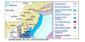
A winter storm is targeting Delmarva later this week. A few hours ago, the National Weather Service issued a Winter Storm Watch for Sussex County and the Lower Eastern Shore of Maryland starting Wednesday evening through Thursday afternoon. Forecasters say heavy snow is possible, with totals between 3-6 inches and travel conditions will be impacted. Then after the storm, strong winds will follow, bringing subzero windchills to the region Thursday night.